You have looked at the Mercator projection your entire life. It hangs in classrooms, dominates digital mapping apps, and shapes how you picture the planet. But there is a massive catch: it is fundamentally lying to you.
Gerardus Mercator drew his famous map back in 1569. His goal was simple and practical. He wanted to help sailors navigate the oceans using straight lines on a flat surface. It was a brilliant tool for crossing seas, but it was never designed to show the true proportions of the earth.
As you move away from the equator on a Mercator map, things stretch out wildly. Greenland looks like a massive landmass that rivals the entire continent of Africa. In reality, Africa is roughly fourteen times larger than Greenland. North America and Europe swell up, while equatorial regions shrink.
The United Nations just decided it is time for a change.
In September 2026, the UN General Assembly adopted a landmark resolution urging member states to phase out the Mercator standard. The initiative was spearheaded by Togo on behalf of the African Union. It passed with an overwhelming 164 votes in favor.
Why does this matter now? Because maps are not neutral drawings. They guide education, feed our collective imagination, and influence how we perceive global power dynamics. When you shrink the Global South for centuries, you subtly reinforce the idea that those regions matter less. Activists and geographers call this distortion out for what it is.
Critics of the change, led notably by the United States, argued that the resolution went too far into political ideology. Washington voted against it, calling the text an unnecessary intrusion into scientific standards. Other nations took the opposite path. France announced it would abandon Mercator for its own official maps, shifting toward alternatives like Eckert IV.
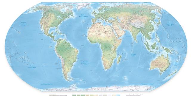
The resolution points toward modern options like the Equal Earth projection, designed in 2018. Equal Earth keeps the actual relative sizes of landmasses intact. Your mental picture of the world shifts immediately when you look at it. Continents return to their proper scales.
Of course, nobody is banning Mercator. You can still use it for navigation or digital routing. The text is non-binding. Countries do not face penalties for keeping old planisphères in classrooms.
Yet, the symbolic shift is massive. A map that respects physical reality does not change the geography of the planet. It simply changes how you see your place in it.
Stop treating flat maps as objective truth. Look at alternative projections today, check out Equal Earth models online, and question the proportions you see in textbooks.