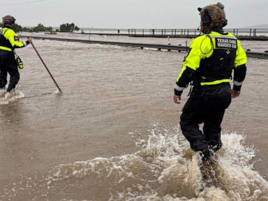
Right now, a massive atmospheric trap is locked over South Texas. The rain just won't stop.
By Wednesday morning, parts of Uvalde County had already been slammed with 16 inches of water. Downpours washed out crucial roads, swallowed farmland, and forced rescue crews into boats to pull people out of submerged vehicles. To make matters weirder and more terrifying, a small tornado touched down in northwestern San Antonio near Interstate 10, ripping through the city while residents watched the twister spin on social media. For a different perspective, read: this related article.
Governor Greg Abbott has already declared disasters across dozens of counties.
But if you think this is just a run-of-the-mill bad storm, you're missing the bigger, scarier picture. The geography of South Texas is essentially built to flood. There is a reason meteorologists refer to this stretch of the state as part of "Flash Flood Alley". Related insight on this trend has been published by Associated Press.
When heavy rain hits this specific region, it doesn't soak into the ground. It immediately turns into a high-speed weapon.
When Tropical Moisture Meets a Stagnant Sky
The physics behind this current deluge are simple but brutal. According to National Weather Service meteorologist Monte Oaks, Texas gets socked with this kind of weather pattern roughly once every five years.
It starts with a stagnant, slow-moving low-pressure system. Normally, weather systems move across the country like cars on a highway. They dump their rain and move on. This one is parked. It is sitting in one spot, acting as a giant atmospheric vacuum cleaner that sucks up massive amounts of wet, tropical air from both the Gulf of Mexico and the Pacific Ocean.
Because the low-pressure system is barely moving, it keeps dumping that moisture over the exact same counties day after day. Forecasters warn that before the system finally drags itself away, some areas could see up to 20 inches of total rainfall.
Think about that number for a second. Twenty inches of rain is nearly two-thirds of what Chicago gets in an entire year, dumped onto Texas dirt in just a few days.
The Balcones Escarpment is a Giant Water Funnel
To understand why this rain is so dangerous, you have to look at the geology underneath the grass. South Texas sits right on the edge of the Balcones Escarpment.
This is a massive geologic fault zone that curves across the state, separating the high, flat Edwards Plateau from the lower coastal plains. When warm, humid air from the Gulf of Mexico blows inland, it hits this steep rise of hills and is forced upward. As the air rises, it cools rapidly, condenses, and squeezes out torrential rain like a wrung-out sponge.
Once that water hits the ground, the real trouble starts.
The Texas Hill Country and South Texas regions feature karst terrain—basically, a lot of hard, eroded limestone covered by incredibly thin layers of clay and rocky soil.
- Zero absorption: Unlike the deep, spongy loam soils of the Midwest, the thin Texas soil saturates almost instantly. Once it is wet, clay acts like concrete.
- Steep slopes: The rugged, hilly terrain means gravity takes over immediately.
- Efficient drainage: Water sheets off the hills and rushes into dry creeks, draws, and river valleys within minutes.
Geologists call this "hydrologically efficient drainage." It sounds like a good thing, but it's a nightmare. It means every drop of rain is directed straight into the nearest river basin with zero delay. A bone-dry creek bed can transform into a roaring, 15-foot-deep river of debris before you even realize it has started pouring a few miles upstream.
The Haunting Memory of the Guadalupe River
The fear in South Texas right now isn't theoretical. It is deeply personal.
Flash flood warnings are active across several counties near the Mexican border, including Kerr County. Local officials there are aggressively contacting summer camps and retreat centers along the water. They have to. Just last year, in 2025, catastrophic flooding along the Guadalupe River killed more than 100 people.
The Guadalupe River is beautiful, but it is one of the most volatile, dangerous rivers in North America. When heavy rain falls over its headwaters, the water has nowhere to go but down a narrow, rocky channel.
State Representative Don McLaughlin warned residents that even during a temporary break in the storms, the danger is far from over. "The rivers and the creeks are going to be coming up, and they're going to be coming up again with a vengeance," McLaughlin said.
In Uvalde, the Leona River has already turned into a boiling torrent of brown water, carrying ripped-up trees, trash, and debris over low-water bridges. The Texas Game Warden Search and Rescue Team has been working constantly, using specialized flat-bottom boats to pull stranded families from their homes.
What to Do When the Water Rises
If you live in or are traveling through South Texas over the next 48 hours, you cannot treat this like a normal rainstorm. Standard safety rules don't cut it when you're dealing with Flash Flood Alley.
Here is what you actually need to do to stay alive.
1. Never Trust a Low-Water Crossing
Texas has thousands of low-water crossings—places where the road dips down to cross a creek bed that is dry 90% of the year. During a stagnant storm system, these are death traps.
- Six inches of fast-moving water can easily knock an adult off their feet.
- Twelve inches of rushing water will float and carry away most small cars.
- Two feet of water will sweep away large SUVs and pickup trucks.
If you see water over the road, you turn around. You don't "test" it. You don't assume your big truck can handle it.
2. Monitor Watersheds, Not Just Your Backyard
Because of how the Balcones Escarpment funnels water, it doesn't need to be raining where you are standing for a flood to hit you. A severe thunderstorm 15 miles upstream can send a wall of water rushing down a creek bed under a perfectly blue sky. Pay attention to regional weather radio alerts and watch the upstream river gauges.
3. Move Up, Not Out
If your home begins to flood, do not try to walk or drive through the water to escape. Unless your home is physically collapsing, the safest place is usually the highest point of the structure. If you must evacuate, do it before the water reaches your property.
4. Have a Go-Bag Ready
If you live near a creek or river basin in the warning zones, pack your essentials now. Include cash, copies of vital documents in waterproof bags, three days of medication, chargers, and hard copies of emergency contact numbers. If local authorities issue a voluntary evacuation order, take it. Don't wait until the game wardens have to launch a boat to get to your front door.